Yangmingshan Summer Getaway: Discover Tianmu Water Pipe Trail, Cuifeng Waterfall and Shamaoshan
Once part of the Grass Mountain Waterworks from the Japanese Era, the Tianmu Water Pipe Trail (aka Tianmu Old
Trail) is now a beloved hiking route in Taipei. Starting in Tianmu, the trail takes you past the stunning
golden Cuifeng Waterfall and up to the uniquely shaped Mt. Shamao.

This trail combines historical significance with natural beauty, offering stunning waterfalls, peaceful woods,
and panoramic views, especially with the hidden gem of Cuifeng Waterfall awaiting exploration.

Disclaimer:
All content is for inspiration only. Use Taiwan Hikes' suggestions at your own risk. We are not responsible for any losses, injuries, or damages.
Taiwan Hikes may include affiliate links. When you purchase through these links, you support our ability to continue providing FREE content — at no additional cost to you.
Table of Contents:
- Trail Information, Map, and Transportation: Tianmu Water Pipe Trail, Cuifeng Waterfall, Hengling Old Trail to Mt. Shamao/Yangming Lake Trailhead – Easy Route
- Trail Information, Map, and Transportation: Tianmu Water Pipe Trail, Cuifeng Waterfall to Mt. Shamao/Dapu Trailhead – More Challenging Route
- About Tian Water Pipe Trail and Mt. Shamao
- Related Posts
Exploring Taiwan? Save Time with the Ultimate 2026 Hiking Guide! Discover the top hikes in every city and
county across Taiwan—all accessible by public transport (bus links available). We've spent 35+ hours
researching the best trails and transit options, so you can skip the hassle and start your adventure! Permit
free!

Trail Information, Map, and Transportation: Tianmu Water Pipe Trail, Cuifeng Waterfall, Hengling Old Trail to Mt. Shamao/Yangming Lake Trailhead – Easy Route
Distance: 8.6 km (5.3 miles)
Route type: point-to-point
Days/Hours Needed: 4-6 hours
Total Ascent/Descent: 802m/432m
Best Time to Go: All seasons.
Permits: Not required
Difficulty Level:
Route type: point-to-point
Days/Hours Needed: 4-6 hours
Total Ascent/Descent: 802m/432m
Best Time to Go: All seasons.
Permits: Not required
Difficulty Level:
Peaks or Places to Reach
- Cuifeng Waterfall
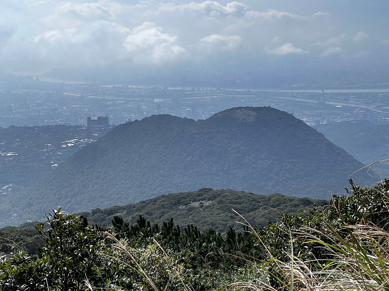
- Mt. Shamao, or Shamaoshan, is 643 meters (2,109 feet) above sea level. On its top is a Class 3 Triangulation Stone. The summit offers a great view of Mt. Qixing Main and East Peak.

GPX Track From My Hike
Click Menu in the map to download, print, or share the map.
You can see more options after clicking the Play button.
Click to change the speed to meet your condition.
You can see more options after clicking the Play button.
Click
to change the speed to meet your condition.
How to Get There by Public Transport: To the Mt. Shamao Yangming Lake Trailhead
Your location ➔ Yangmingshan Bus Terminal ➔ Mt. Shamao Trailhead
Take bus R5 紅5 from MRT Jiantan Station 捷潭捷運站, bus 260 from Taipei Station 台北車站, or Bus 230 from MRT Beitou
Station 北投捷運站, and get off at the last stop.
Walk to the Mt. Shamao trailhead after getting off the bus.
How to Get There by Public Transport: To the Tianmu Water Pipe Trailhead:
There are several buses going to Tianmu. Here, I only list those leaving from MRT Shipai Station 捷運石牌站.
Your location ➔ MRT Shipai Station ➔ Tianmu Stop ➔ Mt. Shamao Trailhead
Your location ➔ MRT Shipai Station ➔ Tianmu Stop ➔ Mt. Shamao Trailhead
You will get off around this Tianmu Bus Stop (map).
- Bus R19 information: get off at the last stop, Tianmu Stop
- Bus 224 information: get off at the last stop, Tianmu Stop
- Chongqing Metro Bus 重慶幹線 information: get off at Tianmu Stop
Brief Itinerary
Tianmu ➔ Tianmu Water Pipe Trailhead ➔ junction to Chinese Culture University ➔
junction to Cuifeng Waterfall ➔ Cuifeng Waterfall ➔ junction to Banling Trail and Banling
Suspension Bridge ➔ Banling Suspension Bridge ➔ Ming Xuan Temple 明玄宮 ➔ Parking Lot
➔ Hengling Old Trail ➔ Yangmingshan Qianshan Park 前山公園 ➔ Mt. Shamao Yangming Lake
Trailhead 紗帽山陽明湖登山口 ➔ Mt. Shamao ➔ Mt. Shamao Yangming Lake Trailhead ➔ Bus 260 stop
My Hike: from Tianmu Water Pipe Trail, Cuifeng Waterfall, to Mt. Shamao Via Yangking Lake Trailhead
I did the easy route with a friend in March 2023, and 1,300 steps awaited us.
10:23 Got off at the Tianmu stop.
10:30 Arrived at the Tianmu Water Pipe Trailhead at Lane 232, Section 7, Zhongshan North Road in Shilin District, and started tackling the
1,300 steps.

10:48 Reach the pond. We took a short break to enjoy the view.
11:07 We reached Zizai Pavilion 自在亭. We took a short break to enjoy the city
view again. Taipei 101 can be seen here.


You will see a stone house under big trees, which is Adjustment Well 調整井. I can't find the jargon for this
name, so I translate it literally from Chinese. This adjustment well was finished in 1929.

The adjustment well was completed in 1929. Water was stored here and then flowed through a large black pipe,
using gravity to power the Sanjiaopu Power Plant 三角埔發電廠 from an elevation of about 300 meters down to 90
meters. However, this function was replaced after the completion of the Feicui Reservoir in 1987.
If you take the steps next to the Adjustment Well, you will find toilets on the right and reach the Chinese
Culture University.

We took the left, and no more steps or steep slopes from here. It was pleasant to walk here. Mt. Datun and
Sulfur Valley Geothermal Scenic Area 硫磺谷遊憩區 can be seen from here, too.


11:44 We arrived at the junction to Cuifeng Waterfall and sat at Cuifeng
Pavilion for another break.

The slope descending to Cuifeng Waterfall was steep and slightly rugged, and finally, my feet could touch
the soil instead of concrete steps.

Cuifeng Waterfall Bathed in the Golden Hue
12:07 We reached Cuifeng Waterfall. I did this hike on Friday, and there
weren't many people around. I could smell sulfur from the waterfall, which is why the boulders in the
waterfall and Song Creek (Songxi 松溪) have a golden hue.

If you are looking for a place to avoid the summer heat in Taipei, this is the perfect place. The water,
sunlight, colors, and sounds are so soothing. I made myself a cup of coffee and sat there to savor the
tranquility.

After the break, we continued the hike. I made a wrong turn during my first hike. If you visit here,
remember to go downhill by following the creek.
Following the creek, we reached a road. The signage points in two different directions to Banling Trail and
Banling Suspension Bridge. We went uphill to the bridge.


Banling Suspension Bridge is small, and you will see residential houses and farms again. Not far from the
houses, we reached City View Platform (lookout) 市景平台.


13:32 The view was great, but the scorching heat from both my hikes made me
continue without staying too long. From here, I saw the Chinese Culture University on my right and Mt.
Shamao ahead of me.
13:34 We reached a junction and Ming Xuan Temple 明玄宮. This place is a
perfect place to have a break. There are toilets (remember to donate some money) and cold drinks if you want
to buy one.

Ming Xuan Temple is also where you decide whether to take the easy or more challenging route to Mt. Shamao.
I took both. You will find details of the more difficult route later.
Exploring Taiwan? Save Time with the Ultimate 2026 Hiking Guide! Discover the top hikes in every city
and county across Taiwan—all accessible by public transport (bus links available). We've spent 35+ hours
researching the best trails and transit options, so you can skip the hassle and start your adventure! Permit
free!

From Ming Xuan Temple to Banling Trail 半嶺步道and Hengling Old Trail 橫嶺古道
We passed some houses and walked on the road before reaching the steps of Banling Trail. We followed the
directions to Hongtan 紅壇 and saw a parking lot.

14:08 The entrance of Hengling Old Trail was easy to spot. Soon, we were
surrounded by beautiful bamboo woods. This section was shaded and flat to enjoy.


14:42 Hengling Old Trail is short, around 800 meters. You will see a sign of
Datunshan, and the end of the trail is connected to Hushan Road Section One 湖山路一段. Turn right, and you will
see the Yangmingshan Bus Terminal.


You can call it a day by taking the bus back home or continuing your hike to Mt. Shamao.
From Shamaoshan's Yangming Lake Trailhead to the Summit
But if you persist, you will be rewarded with great views. The distance from the Yangming Lake Trailhead to
Mt. Shamao is 1 km.
15:23 It didn't take long for us to reach the Yangming Lake Trailhead. From
there, follow the steps.

The first section of the Shamaoshan Trail is the zig-zag steps, and it isn't as steep as some to Mt. Qixing.
We passed the Chen He boundary border 陳何界石 and the old tomb of the mother of Chen Xialin 陳霞林, built in 1832.
Chen Xialin was a Juren 舉人 in the Qing Dynasty. A juren was a successful candidate in the imperial
examinations at the provincial level in the Ming and Qing dynasties. That's the explanation I found on the
internet.


16:05 We arrived at Mt. Shamao, 643 meters above sea level. Standing at the
deck, Mt. Qixing Main Peak, East Peak, and Zhongshan Building 中山樓 were in front of us.


If you are based in Taipei or a visitor, I'm sure you have seen this building. Zhongshan Building is depicted on the back of
Taiwan's 100-dollar banknote.
After spending time admiring the view, we headed to the trailhead.
15:03 It took longer than I anticipated to reach the trailhead. It usually
takes less than one hour.
Trail Information, Map, and Transportation: Tianmu Water Pipe Trail, Cuifeng Waterfall to Mt. Shamao/Dapu Trailhead – More Challenging Route
Distance: 7.1 km (4.4 miles)
Route type: point-to-point
Days/Hours Needed: 4-6 hours
Total Ascent/Descent: 769m/397m
Best Time to Go: All seasons.
Permits: Not required
Difficulty Level:
Route type: point-to-point
Days/Hours Needed: 4-6 hours
Total Ascent/Descent: 769m/397m
Best Time to Go: All seasons.
Permits: Not required
Difficulty Level:
GPX Track From My Hike
Click Menu in the map to download, print, or share the map.
You can see more options after clicking the Play button.
Click to change the speed to meet your condition.
You can see more options after clicking the Play button.
Click
to change the speed to meet your condition.
Brief Itinerary
Tianmu ➔ Tianmu Water Pipe Trailhead ➔ junction to Chinese Culture University ➔ junction to
Cuifeng Waterfall ➔ Cuifeng Waterfall ➔ junction to Banling Trail and Banling Suspension Bridge
➔ Banling Suspension Bridge ➔ Ming Xuan Temple 明玄宮 ➔ Banling Irrigation Canal ➔ Songxi
Waterfall Platform and return the junction ➔ Mt. Shamao Dapu Trailhead ➔ Mt. Shamao ➔ Mt.
Shamao Yangming Lake Trailhead ➔ Bus 260 stop
My Hike: from Tianmu Water Pipe Trail, Cuifeng Waterfall, to Mt. Shamao via Dapu Trailhead
On May 11, 2024, I revisited this route and decided to explore the Banling Irrigation Canal 半嶺圳幹線 after Ming Xuan
Temple and ascended Shamaoshan via the Dapu Trailhead. The trail remained the same until Ming Xuan Temple. Thus,
the following highlights our hike from Ming Xuan Temple to Mt. Shamao via the Dapu Trailhead.

13:22 After the break at Ming Xuan Temple, we followed the Banling Irrigation
Canal. Although it was pretty hot in early May, following this canal gave us a fresh breeze to escape the summer
heat.


13:42 After climbing a few steps, we reached a footpath with a deck overlooking a
creek. A beautiful waterfall was right next to it, and the rocks around it still had a golden hue.

A door blocked the footpath, and a sign posted there stated that this was the residents' water source and asked
visitors NOT to dip their feet in it.

13:46 We returned from the door to locate an entrance to a shortcut to
Shamaoshan's Dapu Trailhead.
14:52 The shortcut was short and had some rough terrain, but we quickly reached
the Dapu Trailhead.

According to the signage at the Dapu Trailhead, the distance from here to Mt. Shamao is 1.2 km. Little did I know
it took me almost 1 hour to reach Mt. Shamao. The hot and humid weather made this step climbing worse, too.


14:43 After the painful ascending, we reached a flat area with building
structures. This building was the Crown Prince's Pavilion 太子亭, built for Crown Prince Hirohito during Japanese
Rule. But he never visited here. You probably won't see this if you go from the Yangming Lake Trailhead.

Within 2 minutes, we reached Mt. Shamao's Class 3 Triangulation Stone and the observation deck to enjoy the view.
15:54 Reached to the Yangming Lake Trailhead and called it a day.
About Tian Water Pipe Trail and Mt. Shamao
Tianmu Water Pipe Trail (aka Tianmu Old Trail)
The Tianmu Water Pipe Road, also known as the Tianmu Old Trail, features a large black water pipe and the
Sanjiaopu Power Plant 三角埔發電廠, both part of the "Grass Mountain Waterworks System" built during the Japanese era.

This historic system is a designated municipal heritage site in Taipei and is the only heritage site classified
as an engineering system. Sanjiaopu is also the old name of Tianmu.
The Tianmu Old Trail is the later section of the ancient Fish Road Trail 魚路古道, which was an important route
connecting Jinshan 金山 and Tianmu. Starting from Tianmu, hikers must climb 1,300 steps to reach the Adjustment
Well, after which the path becomes a flat forest bath trail. Source.
Mt. Shamao or Shamaoshan
Located at the southwest end of Yangmingshan National Park, Shamaoshan is a parasitic volcano of Qixing
Mountain, part of the Datun volcanic group. Its name comes from its resemblance to the traditional black hats 紗帽
worn by ancient officials in China.
The trail, which mainly consists of stone steps, has two trailheads: Yangming Lake Trailhead in the north, near
the Yangmingshan bus terminal, and Qianshan Park, which offers a gentler climb. Dapu Trailhead in the south,
near the first lookout on Shamao Road, is steeper.

Shamao Old Trail is one of the 33 historic trails in Yangmingshan National Park. It is known as one of the "Top
Ten Legends of Yangmingshan 陽明山十大傳奇," written by a Taiwanese mountaineering pioneer, Mt. Lin Zong Sheng 林宗聖, who dedicated
his life to exploring Yangmingshan.
